DOW-UAP-D044
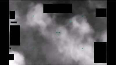
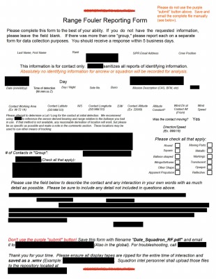
Range Fouler Reporting Form, Gulf of Aden, October 2020
- Agency
- Department of War
- Format
- Document, 1 page
- Incident date
- 10/15/20
- Place
- Arabian Sea
- Released
- Release 01, May 8, 2026
- Source
- war.gov
- Topics
- Infrared / FLIR, Range Fouler, Military aircrew
Description from war.gov
Redactions war.gov lists this record as redacted. Withheld material is blacked out in the file itself.
Page 1
Range Fouler Reporting Form Declassified by MG Richard A. Harrison Declasshmi button above 2 Saye and email the complete file manually (see below). Please complete this form to the best of your ability, If you do not have the requested information, please leave the field blank. If there was more than one "group!" please report each on a separate form for data collection purposes. You should receive a response within 5 business days. Last Name, First Name Rank 0-2 Squadron 172 ATKS SIPR Email Address Crew Position Other This information is for contact only. SPEAR sanitizes all reports of identifying information. Absolutely no identifying information for aircrew or squadron will be recorded for analysis 10/15/20 Date (mm/ddyy) 14:18:39 Time of detection (hh:mmiss Z) Day Day / Night ISR Side No. Buno Mission Description (CAS, BFM. etc) LFE? N E Contact Working Area Contact Latitute N/S Contact Longitude (Ex: W-72 1A) EW (DD:MM:SS) (DD:MM:SS) Please attempt to determine a Lat / Long for the contact at initial detection. We recommend using JMPS to reference the sensor-derived bearing and range relative to the bullseye you had in use. If that method is not available, any reasonable derivation of location will work, but please be as specific as possible and make a note in the comments section. These locations may be used to cue other means of tracking. Contact Altitude (Ex: 22000) Altitude Constant? Wind Dir at Contact All (From) Was the contact moving? Yes Wind Speed Radar Equipped: Stable Trackfile?: # of Contacts in "Group": 1 EA Indications (Check all that apply): AIM-9x Self-Track: ATFLIR Autotrack: Tally Achieved: ECM Arc Letter Identifer False Trackfiles Other/ Ambiguous Direction/Speed 261/30 (Ex. 090/15) Please check all that apply: Round: Moving Parts: Square: Metallic: Balloon-shaped: Markings: Wings/Airframe. Translucent: Other Shape: Opaque: Apparent Propulsion: Reflective: Please use the field below to describe the contact and any interaction in your own words with as much detail as possible. Please be sure to include any detail not included in questions above. Contact at 14:18:39Z to 14:19:522 on 150CT2020. MGRS location 40Q BD 63 1.4 19[1.4a (estimated lat/long While at 19,073 HAT over the Gulf of Aden we tracked a round, cold object in IR traveling 319 degrees at 20 mph. It made a few abrupt directional changes during the 1 minute contact. Our sensor was aimed -50 degrees below our altitude with a slant range of 4.06NM and ground range of 4.78KM. The IR sensor was set to black hot and the object in question was a bright white. (b)(6) Don't use the purple "submit" button! Save this form with filename "Date_Squadron_RF.pdf" and email (b)(6) ] (Also in the global). For troubleshooting, call| (b)(6) Thank you for your time. Please ensure all display tapes are ripped for the entire time of interaction and saved as a .wmv (Example: 4 May VFA-106 HUD.wmv). Squadron intel personnel shall upload those files to the repository located at this link. (b)(6) USCENTCOM MDR 26-0038 to MDR 26-0046 Approved for Release to AARO 03/27/26 000001The text is machine-read (OCR) from the scan and can contain errors. The scan is the record.
Machine summary
Written by Claude Sonnet 4.6 (Anthropic) on May 22, 2026, from the record's text and war.gov's description. It is not part of the record and can contain errors; check it against the document.
DOW-UAP-D044 is a U.S. Navy Range Fouler Reporting Form documenting an incident on October 15, 2020, at 14:18:39Z over the Gulf of Aden. The reporting operator, an O-2 assigned to squadron 172 ATKS in a crew position listed as "Other," observed a single contact via infrared sensor while flying at 19,073 feet. The object was described as round and cold in IR signature, appearing bright white on a black-hot setting, traveling at approximately 20 mph on a heading of 319 degrees (northwest). The contact lasted roughly one minute and included what the observer described as abrupt directional changes. Slant range was 4.06 nautical miles at a sensor depression angle of approximately 50 degrees.
The report is notable for the described flight behavior — abrupt directional changes at relatively low speed — observed through an ATFLIR-type infrared sensor. Personal identifying information for the aircrew and contact point details are redacted under b(6). The estimated MGRS coordinates are partially legible but degraded in the OCR. The document was approved for release to AARO on March 27, 2026, as part of USCENTCOM MDR 26-0038 through 26-0046, placing it within a cluster of contemporaneous CENTCOM-area UAP reports.
Most frequent words
Select one to highlight it in the text above.
Related records
Paired by war.gov 1
Records war.gov itself pairs with this one.
Similar records 8
Closest matches by the text of the documents.
-
 DOW-UAP-D057 Range Fouler Reporting Form, Gulf of Aden, September 2020
9/4/20
-
 DOW-UAP-D042 Range Fouler Debrief, Arabian Gulf, 2023
8/31/20
-
 DOW-UAP-D038 Range Fouler Debrief, Middle East, May 2020
5/14/20
-
 DOW-UAP-D056 Range Fouler Debrief, Arabian Sea, August 2020
8/24/20
-
 DOW-UAP-D058 Range Fouler Debrief, NA, October 2020
10/27/20
-
 DOW-UAP-D091 Range Fouler Debrief, Atlantic Ocean, 2020
2020
-
 DOW-UAP-D089 Range Fouler Debrief, Eastern United States, 2020
2020
-
 DOW-UAP-D090 Range Fouler Debrief, Eastern United States, 2019
2019